

California atmospheric river forces evacuations, road closures

Another round of soaking rain and heavy mountain snow this morning as another atmospheric river storm pounds California. The Atmospheric River currently looks to weaken as it pushes into central and southern California Sunday-Monday, hopefully precluding too many flooding issues over recent burn scars. Heavy snow may pile up over higher elevations of the Cascades, Sierra Nevada, and the Interior West and Rockies this weekend.
LOS ANGELES—An atmospheric river storm is pounding parts of California on Friday after wreaking havoc throughout the state this week, bringing severe storms, mudslides and feet of snow.
Rain, snow and strong winds from the storms Thursday led to issues from San Francisco to Los Angeles, including mudslides in areas recently impacted by deadly wildfires.

(FOX Weather)
The National Weather Service office in Los Angeles said an EF-0 tornado tore through the El Rancho neighborhood in Pico Rivera early Thursday morning. According to the preliminary report, the tornado had winds of 85 mph and was on the ground for about a mile.
The tornado also left behind damage, including several downed trees and exterior damage to homes.

An EF-0 tornado was reported Thursday morning in Pico Rivera, California. Video from the afternoon shows crews removing downed trees after the storm. Thankfully, no injuries were reported.
Video from Thursday afternoon showed crews in Pico Rivera working to remove the downed trees and clear debris.
-

This image shows a tree that was uprooted by a possible tornado in Pico Rivera, California, on Wednesday, March 13, 2025.
(@SupJaniceHahn/X) -

This image shows a tree that was uprooted by a possible tornado in Pico Rivera, California, on Wednesday, March 13, 2025.
(@SupJaniceHahn/X) -

This image shows crews clearing debris after a possible tornado in Pico Rivera, California, on Wednesday, March 13.
(@SupJaniceHahn/X)
Also, amid the torrential rains in Southern California, the Orange County Fire Authority conducted a swift water rescue on Thursday morning after a man was found clinging to a tree in a rushing creek in San Juan Capistrano. Video showed rescue crews rappelling down from a helicopter to pull the man to safety.
SEE IT: CALIFORNIA MAN SAVED FROM RAGING FLOOD IN DARING HELICOPTER RESCUE

Video shows rescue teams saving a person trapped in a vehicle that had become caught in rushing floodwater in San Juan Capistrano, California, on Thursday.
Officials in communities around burn scars created by wildfires, such as the Eaton and Palisades fire in January, issued mandatory and voluntary evacuations due to concerns about debris flows and mudslides that could threaten homes and businesses due to the heavy rain.
Those fears came to fruition near the Lake Fire burn scar in the Santa Barbara area.
BEFORE AND AFTER IMAGES SHOW THE EXTENT OF WILDFIRE DAMAGE AROUND LOS ANGELES

A video shared by the Orange County Department of Public Works shows rocks, sections of trees and mud covering Trabuco Canyon Road after torrential rain fell during an atmospheric river storm that has been pounding California.
The Santa Barbara Office of Emergency Management told residents in communities near the Lake Fire burn scar to shelter in place Wednesday night due to flooding and debris flows that were imminent or occurring.
Precipitation is expected to continue through Friday morning before tapering off by mid-afternoon.
Mudslide rescues take place in San Jacinto

A video shared by CAL FIRE/Riverside County Fire Department shows vehicles that became trapped in a mudslide in San Jacinto amid a powerful atmospheric river storm that has been slamming California.
Multiple mudslides were reported in the city of San Jacinto on Thursday morning, trapping drivers in their vehicles.
According to information provided by CAL FIRE and the Riverside County Fire Department, multiple mudslides were reported just after 6 a.m. PT, and were covering the road at the intersection of Soboba Road and Chabela Drive. Officials said several vehicles were trapped with people still inside. Swift Water Rescue teams were able to walk out six people who were all evaluated by paramedics on the scene and were released.
SEE IT: CAMERA SHOWS FLORIDA TORNADO BARRELING TOWARD FOX 35 ORLANDO TV STATION
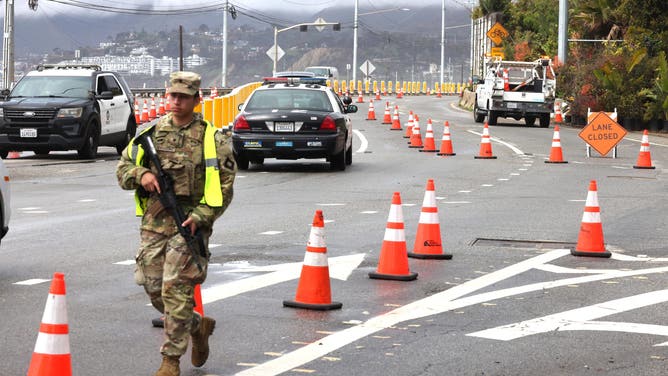
SANTA MONICA, CA – MARCH 12, 2025 – – A member of the California National Guard walks along a checkpoint on Pacific Coast Highway, at Chautauqua Blvd., minutes before it was shutdown in Santa Monica on March 12, 2025. (Genaro Molina/Los Angeles Times via Getty Images)
(Getty Images)
Evacuation warnings were also issued in Malibu, and schools were closed Thursday due to the countless road closures across the region.
The San Bernardino County Sheriff’s Department also issued evacuation warnings, and residents were offered sandbags ahead of the storm to limit potential damage.
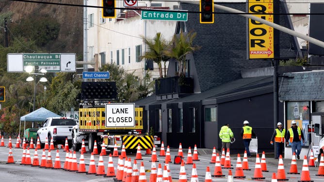
SANTA MONICA, CA – MARCH 12, 2025 – – Workers walk along Pacific Coast Highway, at Estrada Dr.., minutes before the highway was shutdown in Santa Monica on March 12, 2025. Caltrans closed a segment of Pacific Coast Highway to residents and businesses in burn scar areas at noon Wednesday due to safety concerns from the incoming storm. Only emergency vehicles and U.S. Army Corps of Engineers debris-hauling contractors will be allowed through the closure. (Genaro Molina/Los Angeles Times via Getty Images)
(Getty Images)
Members of the Los Angeles Police Department visited homes in the warning areas, and fliers warning of the potential danger were left at homes where no one was available.
Burn scars from wildfires often trigger mudslides and flooding, as the soil in affected areas struggles to absorb water and leads to runoff. Residents across Southern California are being urged to stay vigilant by having multiple ways to receive alerts in case conditions quickly worsen.
While it is late in the season for atmospheric river events, locals said they’ll take as much rainfall as they can as California approaches the typical dry season, which begins in late spring.
EXPLAINING FLOOD ALERTS ISSUED BY NATIONAL WEATHER SERVICE
Severe thunderstorms rock San Francisco Bay Area
Northern California wasn’t immune from the impacts of the atmospheric river either.
A wind gust hit 59 mph at San Francisco International Airport Wednesday afternoon as showers and thunderstorms swept through.
Severe Thunderstorm Warnings covered the San Francisco city area Wednesday afternoon for frequent lightning, strong gusts, pea-sized hail and even a possible tornado – rare for the Pacific coast, where severe weather is rare. It was the second Severe Thunderstorm Warning of the year so far to cover downtown San Francisco. The last time the city saw two Severe Thunderstorm Warnings in one year was Aug. 16, 2020, according to the FOX Forecast Center.
DOWNLOAD THE FREE FOX WEATHER APP

A video shared from San Francisco shows heavy rain falling during a powerful atmospheric river storm that has been slamming California since Tuesday.
Heavy snow also causes problems
In addition to heavy rainfall, snow levels are expected to drop significantly in the Sierra Nevada Mountains, with several inches to several feet of snow forecast at higher elevations. According to computer forecast models, up to 3-4 feet of snow is expected to accumulate, helping to create an enhanced snowpack in areas where it has been below average this season.
A Winter Storm Warning is in place for the Sierra Nevada, including Yosemite Valley. Gusting winds up to 60 mph and up to 18 inches of snow are making travel difficult in the mountain passes.
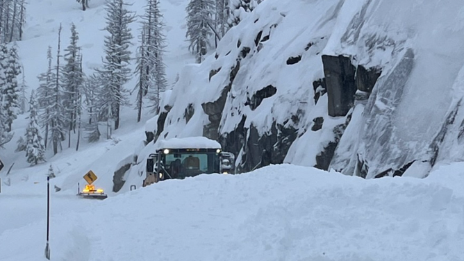
Crews clear snow on U.S. 50 at Echo Summit in South Lake Tahoe, California on March 13, 2025.
(CHP South Lake Tahoe)
In Olympic Valley, Palisades Tahoe ski resort reported 25 inches of snow on Thursday morning as more snow was expected through Friday.

In Olympic Valley, Palisades Tahoe reported more than 2 feet of snow Thursday morning. Pretty scenes from around the resort show the snowfall, as well as workers clearing snow.
Source link
editor's pick
latest video
Sports News To You
Subscribe to receive daily sports scores, hot takes, and breaking news!


