

Severe storms and potential for a foot of rain threaten central US this week
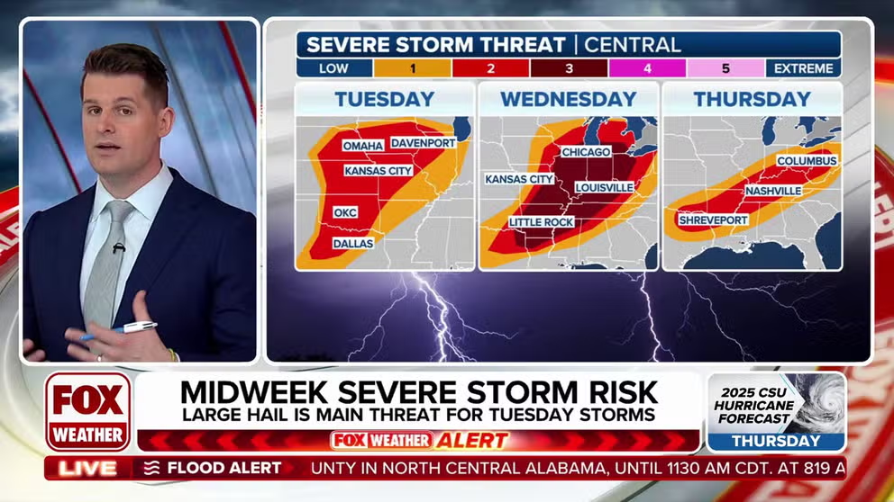
The FOX Forecast Center is monitoring our next severe weather threat, which kicks off Tuesday in the central Plains yet again. Severe thunderstorms are expected to develop Tuesday night from Kansas to Illinois, with large hail being the main threat.
ST. LOUIS – Yet again, another round of severe weather is set to threaten the central U.S. with damaging winds, large hail and tornadoes starting later Tuesday and continuing through Thursday. Simultaneously, a significant risk of extreme flash flooding is growing for the Mississippi and Ohio valleys this week, where some areas could see nearly a foot of rain.

(FOX Weather)
The FOX Forecast Center said a strong storm system is strengthening over the western U.S., which will send a cold front and warm front into the central Plains and Midwest. Severe thunderstorms are expected to develop late Tuesday or Tuesday night from Texas to Illinois.
While storms will struggle to form during the day Tuesday due to a strong “cap” – an atmospheric lid that inhibits thunderstorm development – a few isolated storms could develop along the dryline in Oklahoma and Texas, bringing a low chance for hail or strong wind gusts.
WATCH VS. WARNING: HERE ARE THE DIFFERENCES BETWEEN THESE WEATHER TERMS THAT COULD SAVE YOUR LIFE

(FOX Weather)
After sunset, the severe weather threat will increase as storms form along and north of a warm front lifting across Kansas and Missouri. While there is some uncertainty about storm coverage farther south along the cold front, if any storms do develop, they could bring damaging winds and possibly a tornado risk.
Multiday severe weather threat peaks Wednesday, lingers into Thursday
A significant severe weather threat is anticipated Wednesday, stretching from Lower Michigan and the Ohio Valley southwestward through the mid-South and southern Plains, the FOX Forecast Center said.
Storms are likely to be ongoing or developing early in the day from Wisconsin to Oklahoma and Texas. As a strong storm system moves across the northern Plains and a cold front pushes eastward, warm, humid air will create a favorable environment for severe thunderstorms.
DOWNLOAD THE FREE FOX WEATHER APP

(FOX Weather)
This setup may favor isolated supercell thunderstorms, increasing the potential for very large hail, especially farther south, as well as widespread damaging winds and a significant risk of tornadoes, some of which could be EF-2 or stronger, the FOX Forecast Center said.
Storms will continue through the evening and overnight, moving eastward across the Midwest and lower Mississippi Valley.
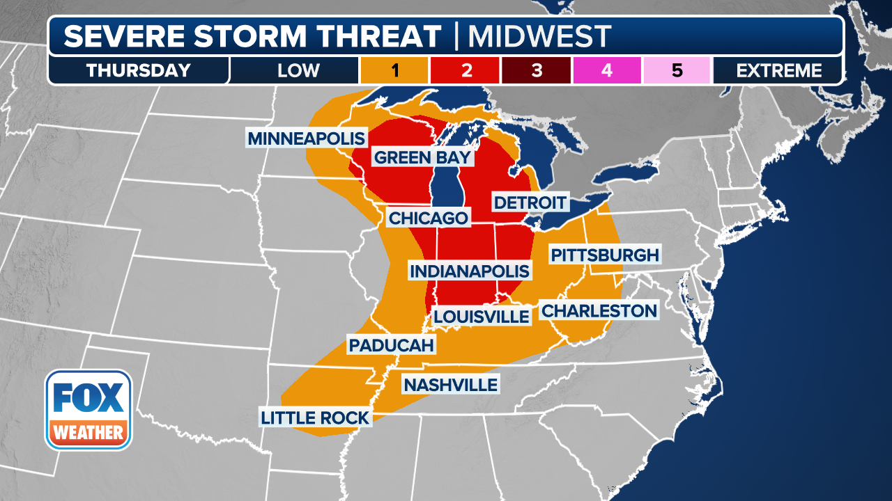
On Thursday, the cold front will slow and stall from the Mississippi and Ohio valleys into the southern Plains. Even as the main storm system moves into Canada, daytime heating and high humidity will fuel another round of severe storms, with damaging winds, large hail and tornadoes possible, the FOX Forecast Center noted.
(FOX Weather)
Rainfall totals could approach a foot across parts of Tennessee, Kentucky
The FOX Forecast Center is also monitoring a growing threat of extensive flash flooding in the Mississippi and Ohio valleys this week, coinciding with the severe weather.
Repeated storms moving over the same areas – known as training – are expected, with computer forecast models indicating 24-hour totals exceeding 5-8 inches in some spots, particularly from Arkansas into western Kentucky, on top of previous days’ rainfall.
While 3-5 inches of rain could fall from Wednesday into Thursday, prompting early flash flood alerts, the FOX Forecast Center warned that the primary period of concern will linger into the weekend. By the end of the week, rainfall totals could approach a foot, creating a potentially dangerous situation given the region’s already-saturated conditions.

(FOX Weather)
A level 3 out of 4 flash flood risk is currently in place for Wednesday. By Thursday, the expected prolonged heavy rain continues the level 3 flash flood threat for parts of western Tennessee and Kentucky, with a potential upgrade to the highest threat level. The level 3 risk zone shifts slightly to the southwest on Friday.

(FOX Weather)
The unsettled pattern continues into Saturday as well, with the potential for heavy rain and severe storms in parts of the Mississippi and Ohio valleys.
Winter weather threat returns to areas impacted by recent ice storm
The FOX Forecast Center said there is a decent chance of seeing 4-plus inches of snow in parts of the Dakotas, northern Minnesota and the Upper Peninsula of Michigan from Tuesday into Wednesday.

(FOX Weather)
In addition, wind gusts are expected to range from 30-40 mph, which could create near-blizzard conditions with blowing snow, especially in areas with heavy snowfall.
The winter weather could impact the same region hit hard by a destructive winter storm that brought crippling ice accretions over the weekend.
Source link
editor's pick
latest video
Sports News To You
Subscribe to receive daily sports scores, hot takes, and breaking news!


