Severe storms charge toward East Coast threatening 87 million with damaging winds
Severe weather is moving across the Southeast Monday morning. Those storms are forecast to intensify across Alabama, Georgia and into the Carolinas late afternoon and into Monday evening. Commuters in the Mid-Atlantic up to New York City will deal with heavy fog in the morning, isolated severe storms and winds are possible in the afternoon.
ATLANTA – Commuters woke up to a line of severe thunderstorms tracking through the Southeast Monday morning as another round of severe storms threatens some 87 million people across the eastern U.S. with damaging winds and a few tornadoes.
While the tornado threat is greatest from southern Mississippi through the Carolinas, the threat of damaging winds extends northward to Pennsylvania, New Jersey, the New York City metro area and parts of central and upstate New York.
These storms are associated with the same system that pummeled the central part of the country Sunday, leaving at least two people dead in Indiana. Tornadoes were spotted in several states, and the National Weather Service received dozens of wind and hail reports.
Where is severe weather happening now?
As the strong cold front driving the severe storms charges eastward on Monday, some 87 million people from the Northeast southwestward to the central Gulf Coast region face the threat of severe weather to kick off the new workweek.

(FOX Weather)
NOAA’s Storm Prediction Center (SPC) has issued Severe Thunderstorm Watches for parts of several states in the Southeast as the major storm system barrels across the region Monday morning.
WATCH VS. WARNING: HERE ARE THE DIFFERENCES BETWEEN THESE WEATHER TERMS THAT COULD SAVE YOUR LIFE

(FOX Weather)
Timing for Monday’s severe storms
Strong to severe thunderstorms packing threats of damaging wind gusts and a few tornadoes are expected Monday from portions of the Northeast southwestward to the central Gulf Coast region, threatening both the morning and evening commutes.
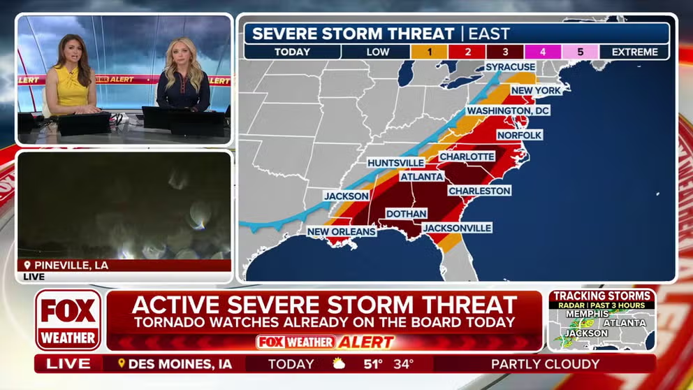
NOAA’s Storm Prediction Center (SPC) has posted a level 2 out of 5 severe weather risk that stretches from southeastern New York state to southeastern Louisiana. However, a level 3 out of 5 severe weather risk covers much of the mid-Atlantic and Southeast, from central North Carolina to southern Mississippi.
Storms are already ongoing near the Gulf Coast and parts of the Southeast, with additional development expected farther north throughout the day, the FOX Forecast Center said. While the atmosphere will only be modestly unstable in the Northeast, storms in this region could still produce strong winds.
The severe weather threat will continue into Monday evening before the storms weaken as they move offshore.
TORNADO SAFETY: HOW TO IDENTIFY THE SAFEST PLACES INSIDE YOUR HOME

(FOX Weather)
While the highest concentration of wind damage is forecast to be centered over parts of the Carolinas, Georgia, Alabama, southern Mississippi and the Florida Panhandle, a notable threat extends up much of the East Coast, including major cities along the Interstate 95 corridor such as Washington, Baltimore, Philadelphia and New York City.
The damaging winds could take down trees and power lines, potentially causing widespread power outages in some areas.
DOWNLOAD THE FREE FOX WEATHER APP

(FOX Weather)
Source link
editor's pick
latest video
Sports News To You
Subscribe to receive daily sports scores, hot takes, and breaking news!


