Historic flash flood worries grow in mid-South with over a foot of rain possible
Fast Facts:
- A strong storm system will bring widespread thunderstorms and heavy rain to the central U.S.
- Significant flash flooding is expected in the Mississippi and Ohio valleys through Saturday.
- Repeated storms along a slow-moving front will cause a high flash flood risk, especially in western Tennessee and Kentucky.
- Rainfall totals could reach over 5-8 inches in some areas, with local amounts up to a foot.
With the potential for once-in-a-lifetime rainfall and widespread impacts, historic flash flooding is increasingly likely across parts of the nation through Saturday, fueled by repeated rounds of storms accompanying a rare high-level severe weather threat, forecasters warn.
A strong storm system is taking shape in the central U.S. on Wednesday, bringing widespread thunderstorms with a deluge of drenching rain. With a surge of moisture and instability fueling storms along a slow-moving front, the risk of flash flooding will be high.
“The forecast heavy rainfall in this event has a return interval of anywhere from 25 to 100 years,” the National Weather Service in Little Rock, Arkansas, said. “In other words, a heavy rainfall event of this magnitude falling within four days is an event that happens once in a generation to once in a lifetime. Historic rainfall totals and impacts are possible.”
LIFE-THREATENING TORNADO OUTBREAK EXPECTED WEDNESDAY AMID RARE HIGH-RISK SEVERE WEATHER THREAT

(FOX Weather)
The greatest concerns stretch from the Mississippi Valley into the Ohio and Tennessee valleys, where repeated rounds of storms will likely bring significant rainfall totals with local amounts up to a foot by the weekend, the FOX Forecast Center said. As much as 3-5 inches of rain could fall from Wednesday into Thursday alone, leading to early flash flood concerns.
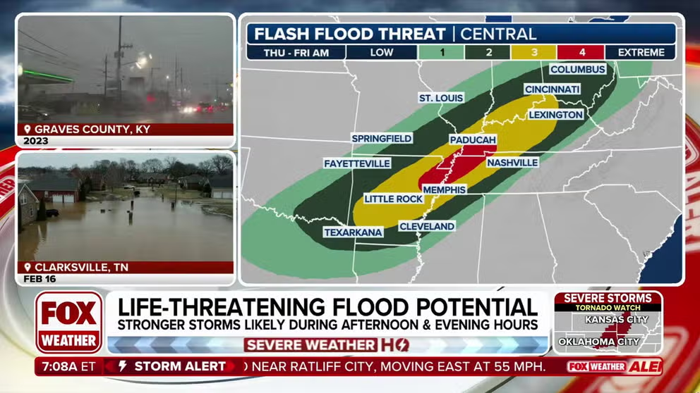
Currently, a Level 3 out of 4 flash flood risk is in place for Wednesday, and by Thursday, the slow-moving front is expected to stall, leading to prolonged heavy rain over many of the same areas.

(FOX Weather)
Due to this, the highest level of flash flood risk has been issued for Thursday in parts of western Kentucky, the Bootheel of Missouri, West Tennessee and northeastern Arkansas.
DOWNLOAD THE FREE FOX WEATHER APP

(FOX Weather)
The FOX Forecast Center said concerns are that storms will move over the same area over and over, a process called “training.” Computer forecast models have been indicating several-inch rainfall totals, especially across Arkansas into western Kentucky, where 24-hour totals in excess of 5-8 inches are possible in some spots. This is on top of several inches of rain that will have already fallen in previous days.
“This is an increasingly significant setup approaching with potential for high impacts and life-threatening flash flooding spanning the course of several days,” NOAA’s Weather Prediction Center (WPC) said. “Be sure to prepare if you live in a flood zone anywhere from Arkansas, northeast through the Ohio/Tennessee valleys.”

(FOX Weather)
The unsettled pattern will continue into Friday and Saturday, with heavy rain and severe storms potentially persisting. By the end of the week, rainfall totals could approach or exceed a foot.
The National Weather Service in Paducah, Kentucky, said storm total rainfall now ranges from 8-12 inches over the Quad State, with the highest amounts straddling the Ohio River and the lowest amounts in the far northwest and the far southeast.
“If we get anywhere near these amounts, a historic flash flooding event is likely over a large portion of the Quad State,” the agency warned. “Widespread river flooding will likely develop as well.”
Flood Watches have been issued from northeastern Texas through central Ohio, covering over 900 miles and affecting more than 20 million Americans.
Source link
editor's pick
latest video
Sports News To You
Subscribe to receive daily sports scores, hot takes, and breaking news!


