Why is this relentless severe weather pattern stuck over the eastern half of the US?
CINCINNATI – Days of relentless rain and severe storms in the Mississippi and Ohio River Valleys may have many wondering why the weather has been stuck, as if the forecast has been on repeat.
The answer, according to meteorologists, lies in the weather patterns, which have produced prolonged periods of severe weather.
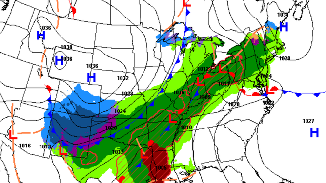
Ridges of high pressure, currently generally centered over the eastern U.S., have, in essence, trapped storm systems over the heartland, preventing them from moving eastward.

U.S. weather synoptic scenario
(NOAA)
This stagnation in the weather pattern has allowed storms to repeatedly hit the same areas, leading to heavy rainfall and severe weather in cities such as Cincinnati, Louisville, St. Louis and Memphis.
Essentially, the region has been dealing with a stationary frontal boundary and areas of low pressure that are either slow-moving or stuck over the region, leading to storms training over the same areas and an amplified flood risk.
WATCH: VIOLENT TORNADO CAUSES DAMAGE NEAR LAKE CITY, ARKANSAS
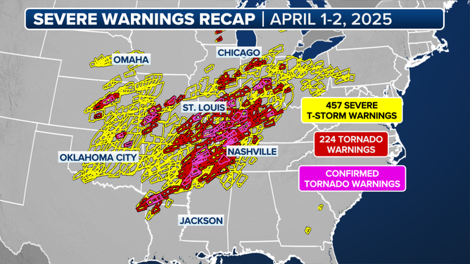
And the severe weather has certainly made its mark. According to the FOX Weather Center, more than 600 severe weather alerts were issued from Wednesday into Thursday, the most since 2012.
While the number of tornadoes, hail, and damaging wind events is only slightly above average for the time of year, the issue has been the sheer scale of the impacts, with flooding affecting some of the same communities.

Severe weather warnings recap
By the time all the rain has fallen, many areas will have received over a foot of rainfall, leading to saturated soils.
River levels, however, commonly lag behind rainfall totals, meaning that the full extent of the flooding will not be immediately known for days after the rainfall ends.
According to NOAA water-level sensors, only two river gauges in the U.S. are currently at major flood stage, with that number expected to jump to 38 over the next few days.
The same can be said for river levels at minor or moderate stages, with a significant jump expected in the short to medium term.
DEADLY TORNADO OUTBREAK PUMMELS MISSISSIPPI VALLEY AS STATES OF EMERGENCY DECLARED
End of current stagnant pattern in sight
The pattern of stormy weather is not expected to last forever, as widespread weather patterns typically last anywhere from a few days to under two weeks.
High-pressure ridges along the Eastern Seaboard, which have kept the storm systems locked in place, are finally expected to weaken toward the end of the weekend and into next week.
This shift will allow drier, less humid air to percolate, bringing an end to the wet and humid weather that has plagued the region.
ATTITUDES TOWARD TORNADO PREPAREDNESS IN US CHANGING AS STORM RISK ZONES SHIFT
While the prospect of drier weather is welcome, the floodwaters will not recede quickly.
River levels will remain high for the foreseeable future, and if a wet weather pattern returns, any additional rainfall could be especially serious.
Interestingly, the Ohio Valley region was one of only a few across the country expected to see above-average precipitation during the spring.
This is occurring while the mid-Atlantic, Florida and the desert Southwest are grappling with drought conditions and record heat.

(FOX Weather)
Source link
editor's pick
latest video
Sports News To You
Subscribe to receive daily sports scores, hot takes, and breaking news!


