Severe storms target Midwest, South threatening Easter travel for millions

Easter travel could be snarled across wide areas of the US as a multi-day severe weather threat lingers through Sunday.
KANSAS CITY, Mo. – An active stretch of severe weather is expected to develop late this week and continue into the Easter weekend from the Midwest to the Mississippi Valley.
At this time, hail and damaging winds appear to be the main threats, although Sunday may end up with a higher tornado threat, the FOX Forecast Center said.
“Since April 1, we have only had three days where we haven’t had some sort of severe storm threat,” FOX Weather Meteorologist Zack Green said.

(FOX Weather)
As afternoon temperatures build from central Nebraska to central Iowa – which includes the Lincoln, Omaha and Des Moines metro areas – severe thunderstorms could produce a couple of tornadoes, damaging winds of 60-plus mph and very large hail, perhaps up to the size of golf balls or even baseballs.
Some storms could develop into supercells and produce a very large hail swath. A zone of smaller, scattered hail-producing storms north of the warm front in northern Iowa, southern Minnesota and southwestern Wisconsin could also develop, the FOX Forecast Center said.

(FOX Weather)
By Friday, the threat of severe weather will shift east and expand from the southern Plains into the Great Lakes region. Numerous thunderstorms are expected to develop in the afternoon and evening.
The FOX Forecast Center said the environment will support a broad area of severe storms, potentially affecting a large area extending from Detroit to Chicago southwestward to Kansas City, Missouri; Oklahoma City, Oklahoma; and northwest of the Dallas–Fort Worth Metroplex in Texas.
These storms will primarily pack a damaging wind and large hail threat. The tornado risk, while not zero, will be low due to a lack of individual supercells. Instead, clusters of storms will develop along the cold front.
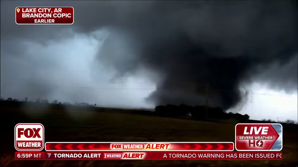
Brandon Copic was chasing storms in Arkansas when a massive wedge tornado formed in front of him.
Easter weekend remains active
Scattered severe storms remain possible from Central and North Texas to the Ohio Valley and western Pennsylvania on Saturday afternoon and evening. As storms repeatedly drench the same areas, this will signal the beginning of heavy rain and possible flooding, the FOX Forecast Center notes.
Across Texas, including the Dallas-Fort Worth Metroplex, the forecast is a little more uncertain due to the presence of morning thunderstorms. These morning storms could “eat up” the available energy in the atmosphere and limit activity later in the day. Should the storms develop, damaging wind gusts of up to 60 mph and hail are the main concerns. A tornado or two can’t be ruled out.

(FOX Weather)
Easter Sunday will be a day to watch as ingredients may come together for a more formidable severe weather event, including more tornadoes.
A region that has been hit very hard by severe weather over the past month may be in the crosshairs: portions of the southern Plains, lower and mid-Mississippi Valley and mid-South region.
Details will become clear as the event draws closer. Stay with FOX Weather for the latest developments.
Source link
editor's pick
latest video
Sports News To You
Subscribe to receive daily sports scores, hot takes, and breaking news!